Originally published in 2014, but updated due to numerous recent enquiries.
Over the years, I’ve seen a lot of people looking for test route information. Once upon a time, official test routes were published by DVSA (when it was still DSA) and available for download. They stopped publishing them in 2010, but that didn’t prevent people who had already downloaded them circulating them. In later years – even right now in 2021 – certain unscrupulous instructors and money-makers were even selling them at silly prices.
One major problem with test routes is that they change over time as DVSA adds new ones or removes others. They can even change on the day of the test for reasons such as roadworks or road closures. And unless they are being officially published you have no way of knowing if ones given to you are correct – or if someone has just cobbled together some old information into a crude list of road numbers and names and perhaps charged you a tenner for it. I can absolutely guarantee that many of those advertised on old-fashioned HTML websites are these original out-of-date lists. The other major problem is that deliberately trying to teach just test routes doesn’t get better pass results, but it does produce less able drivers.
You don’t really need to know the precise test routes used. All you need is a general awareness of key features where pupils might have problems.
It isn’t difficult to work out where the examiners go on driving tests, even without using technology. They’re never going to travel more than about 20 minutes away from the test centre in any direction, so all the roads leading to the test centre are going to be involved (minus motorways in most cases). If you know the examiners to look at, you’ll see them from time to time during your lessons, so you now know they use that road or location. You can also ask your pupils where they went after their tests, and although this can produce more confusion than it does answers, you might be able to extract a bit of useful information. The examiner will often give you some details in the debrief, especially where faults were committed. And finally, you can sit in on tests (when there isn’t a pandemic) and actually watch where they go. You can quickly work out which specific areas to concentrate on by putting all of this together into your lesson plans.
The best way, though, is to use some sort of tracking device, which logs the precise route taken by the car. These days, most satnavs have a feature which allows you to do this. Personally, I don’t like that method because it tends to be tied in with the satnav software, be satnav-specific, and it can be a right pain trying to download it and manipulate it on standard mapping software. The other problem is that you’re unlikely to be able to leave it running while someone is out on test, because the examiner will be using theirs, and thinking back to my old satnav years ago, it didn’t always get a signal if it wasn’t stuck on the windscreen. I’m not saying they’re like that now, but they are designed to be used in that position – and not in the glove box. And the other weakness is that the satnav is the recorder, so you have to wait until the test is over and you can grab it before you know where it went.
Dashcams are another way. The better ones also record GPS data, though often – like satnavs – you can only manipulate this within the camera manufacturer’s specific software. And again, you only get to see it after the event.
A third option is to use one of any number of apps for smartphones. These log routes in a format that mapping software understands. I’ve tried them, and they do work – with a few limitations. Firstly, you would need to leave your phone in the car when it went out on a test, meaning you’d be phoneless for the duration. A spare phone would work, but obviously this feature uses data, so you’d need a separate phone account. And when I tried them, the free versions of apps tended to be restricted to sample rates of 20-30 seconds – and that could mean a route through a junction and roundabout system might show as a straight line across a field or lake. If you wanted a 5 second sampling rate, you had to subscribe.
My solution was to use a dedicated tracker. I use a ProPod tracker from Trackershop. It’s a small device the size of a matchbox, which I keep in the car. The main feature for me, apart from logging accurate position and even postal locations, is that it broadcasts its location in real-time. This means that at the test centre, I can watch the car moving on a map overlay (either on my laptop or the Trackershop app on my phone). It also means that if a test were abandoned for some reason – and that hasn’t happened yet – I’d know exactly where to go to find my car and pupil.
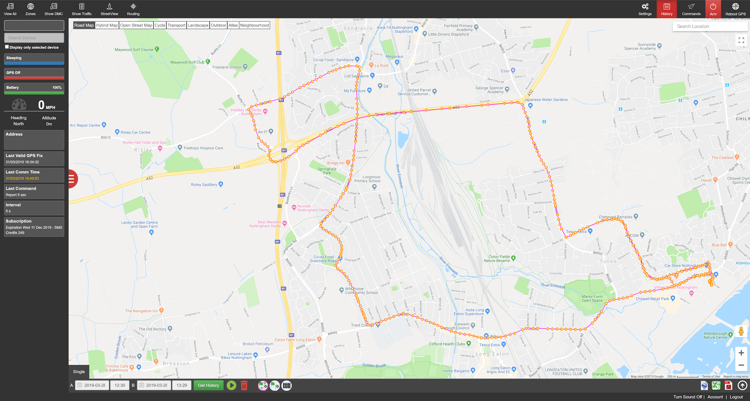
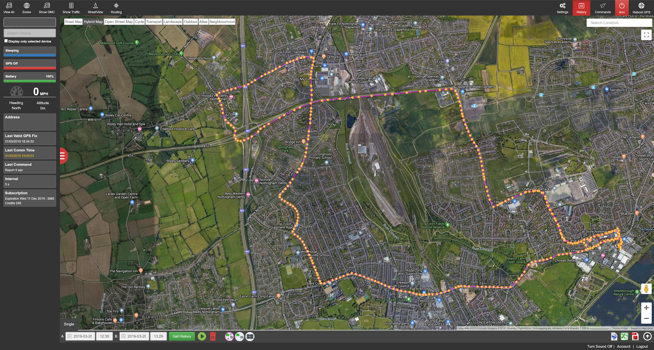
The picture at the top of this article shows an old test route for Chilwell Test Centre (click on the image for a larger view). This is my tracker dashboard ‘history’ view, with a specific historical time period displayed (the duration of the test in question) on a map overlay. The picture just above (click it for a larger image) is the same route with the satellite view enabled. You can zoom in almost to the level where pedestrians would be visible.
The Trackershop cloud service keeps journey history permanently (as long as you have an active account), and you can download and edit data as necessary whenever you feel like it – you just need to to know the date and time of a past test, for example, then go and find that route in your dashboard. As I mentioned, you can view data in real time on whatever overlay you have chosen, and watch the pointer moving every 5 seconds while your pupil is out on test – I find this useful for knowing when they are due back.
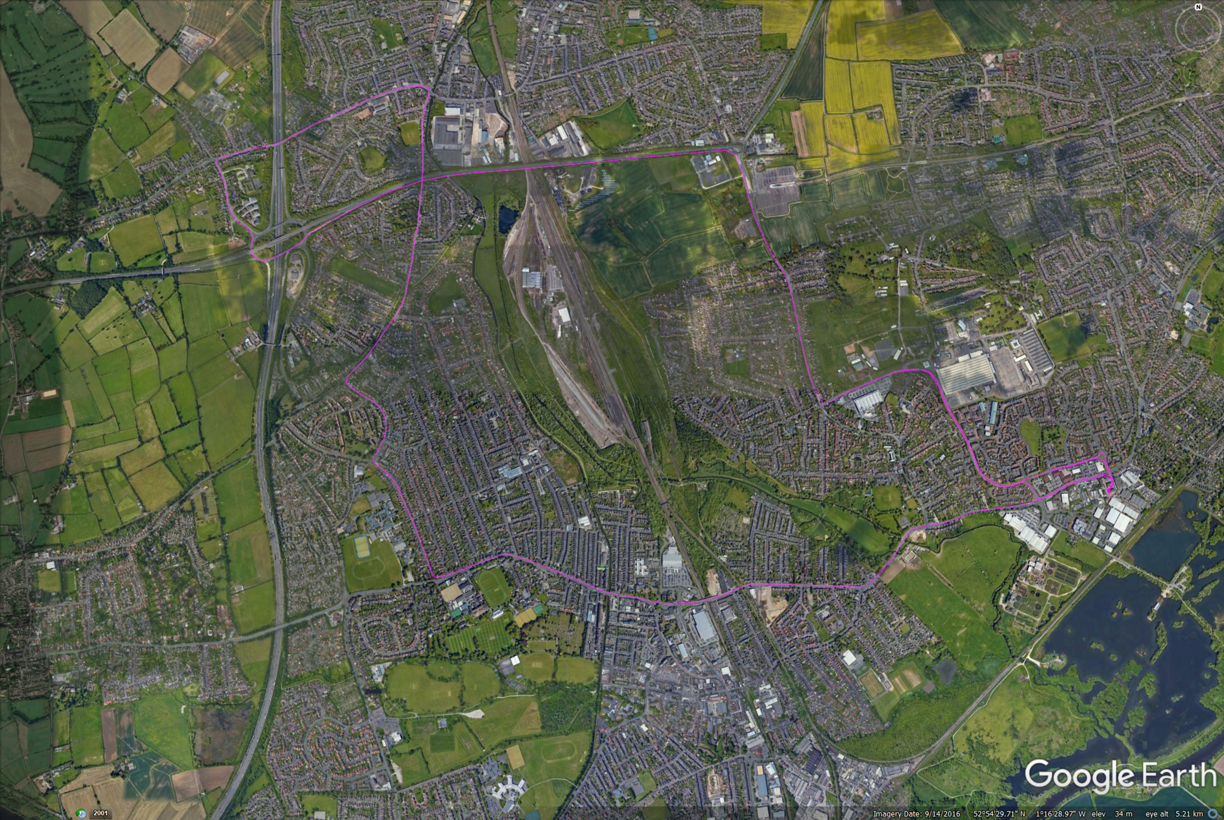
The cloud data can be easily exported and downloaded. As well as GPS coordinates it logs times, speeds, and postal addresses for every data point. The picture above (click it for a larger image) shows the same test route displayed as a KML file rendered in Google Earth (note that I had to physically extract the GPS data to create this, but it isn’t difficult if you know what you’re doing).
As I have already indicated, you should not be doing your lessons across such precise routes. But they do give you an idea of where tests go.
Where can I download test routes?
You can’t download them from DVSA. The sites that offer them are provided by people trying to earn money from something that is otherwise simple to do yourself. Given that test routes change over time, it is probably cheaper to record your own.
Why don’t you provide your test route data?
A point of principle. DVSA stopped publishing them because instructors were trying to teach only the test routes, and I know full well that that’s why people want the information now. My logged routes are for my own use – I don’t stick to test routes on lessons and never have, but I want to know where the routes are so I can deal with any weird stuff.
Should I pay for downloadable test routes?
My advice would be no. DVSA stopped publishing them for a reason, and if someone is trying to profit from selling them then he or she is going against that. There’s a good chance you’re being sold old routes, anyway, and you would never know if they changed unless you kept on buying them every month or so.
How do I know the routes I’ve bought are correct and up to date?
You don’t, and they’re probably not. In fact, unless a local group of ADIs is giving you daily copies, they couldn’t possibly be reliable. In the worst case, they could be totally imaginary and simply cobbled together to be reasonably close to actual routes. Judging by some of the ancient-looking sites that list them, they’re quite likely to be the original ones that they stopped publishing in 2010. As I said above, routes change with time.
Is it possible to record test routes?
Yes. There are free and paid for apps available for both Android and iPhone which use GPS to record journeys. Similarly, there are numerous GPS tracker devices available which do the same (I use a Pro Pod tracker). If you use a phone app as a logger, you have to leave a phone in the car.
You can also record routes using dashcams. As well as using my tracker, I also have a dashcam recording all the time. On more than one occasion I have been able to show a pupil exactly where and why they failed, even though they had no idea what the examiner was talking about in the debrief.I would strongly recommend the ProPod range of trackers from TrackerShop, but others are available. Due to a very poor experience some years ago I would strongly advise against any tracker by Rewire Security (they sold me the device on lifetime subscription, then cut that service off and made it repeated subscription – they cannot be trusted, and I will never forget it).
Do I need to know the test routes for my test?
Absolutely not. The examiner will give you directions as necessary, or ask you to follow the satnav or road signs. However, if there are one or two awkward features – big roundabouts, steep hills, or so on – your instructor should know about them and make sure you know how to handle them well before your test.
How many test routes are there?
It varies from test centre to test centre, but there could be 10, 20, or more. When they were still published by DVSA (while it was still DSA), one Nottingham test centre had 38 if I remember correctly. You couldn’t possibly memorise all of them even if you knew them all. Being brutally honest, many learners on test might not recognise their own streets when out on test, so how can they be expected to ‘remember’ multiple routes?
Can I use my tablet to log routes?
Potentially, yes. If it has a GPS chip inside, it doesn’t necessarily need to be connected to the internet or a phone network to log GPS positional data, though it would if you wanted to use it as a satnav or monitor it in real-time. However, you’d need some software that could make use of the chip. It would also depend on your device’s specification as to how accurate the data were, but you’d still be able to get decent route maps – they just wouldn’t always be necessarily precisely lined up with the roads on maps you laid them on to. I understand they are accurate to around 6 metres or better.
From what I know of Apple iPads, only the more expensive ones with phone connectivity have GPS chips in them. The WiFi only ones don’t.